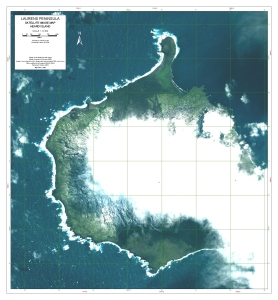
Map 13030: Laurens Peninsula : satellite image map, Heard Island
Map details
| Map Number | 13030 |
| Title | Laurens Peninsula : satellite image map, Heard Island |
| Edition | 1 |
| Scale | 1 : 12 500 |
| Publication date | October 2003 |
| Publisher |
Australian Antarctic Division (Australia)
|
| Spatial coverage |
( 73.2333° -52.9500°)
,
( 73.3500° -52.9500°)
,
( 73.3500° -53.0333°)
( 73.2333° -53.0333°) |
| Projection | Universal Transverse Mercator |
| Physical size | 69 x 64 cm |
| Notes | Digital Globe Multi Spectral Image. Image acquired 4 February 2003 with approx. 25% cloud cover. A copy of this map in the form of a PDF file (Adobe Portable Document Format) is available upon request from the Australian Antarctic Data Centre. The file is 61 Mb. |
| Keywords | Laurens Peninsula , Heard Island , Satellite Imagery |
Downloads
No downloads available.
This is a hard copy map. See information about obtaining copies of hard copy maps.
Map Lists
This map belongs to the following lists. Use the link on the list to see all maps belonging to that list
Additional Information
| Horizontal datum | WGS84 |
Preview