Map 13038: McDonald Islands : satellite image map
Map details
| Map Number | 13038 |
| Title | McDonald Islands : satellite image map |
| Edition | 1 |
| Scale | 1 : 7500 |
| Publication date | February 2004 |
| Publisher |
Australian Antarctic Division (Australia)
|
| Spatial coverage |
( 72.5667° -53.0167°)
,
( 72.6667° -53.0167°)
,
( 72.6667° -53.0583°)
( 72.5667° -53.0583°) |
| Projection | Universal Transverse Mercator |
| Physical size | 63 x 83 cm |
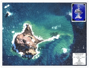
| Notes |
Image acquired 9 April 2003 with less than 5% cloud cover. Digital Globe Pan Sharpened Image, georeferenced from the Satellite Ephemeris data. The map includes an aerial photograph of McDonald Islands taken on March 11, 1980 as an inset. |
| Keywords | - |
Downloads
This is a digital map available for downloading.
Map Lists
This map belongs to the following lists. Use the link on the list to see all maps belonging to that list
Additional Information
| Horizontal datum | WGS84 |
Preview