Map 13041: Beaver Lake: Aerial Photography Flight Lines and Photo Centres
Map details
| Map Number | 13041 |
| Title | Beaver Lake: Aerial Photography Flight Lines and Photo Centres |
| Edition | 1 |
| Scale | 1 : 100 000 |
| Publication date | September 2003 |
| Publisher | - |
| Spatial coverage |
( 66.7300° -70.2983°)
,
( 69.0433° -70.2983°)
,
( 69.0433° -70.9350°)
( 66.7300° -70.9350°) |
| Projection | Universal Transverse Mercator |
| Physical size | 86.5 x 70 cm |
| Notes |
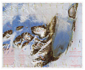
The map shows flight lines and photo centres for aerial photography flown for the Australian Antarctic Division (AAD) over the Beaver Lake area. The flight lines and photo centres are superimposed on the AAD's 1:100,000 Beaver Lake satellite image map. |
| Keywords | Prince Charles Mountains |
Downloads
This is a digital map available for downloading.
Map Lists
This map belongs to the following lists. Use the link on the list to see all maps belonging to that list
Additional Information
| Horizontal datum | WGS84 |
| Vertical datum | 69.9 degrees west in 1990 |
| Nomenclature | Australian Antarctic Gazetteer |
Preview