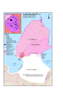
Map 13101: Azorella Peninsula, Heard Island
Map details
| Map Number | 13101 |
| Title | Azorella Peninsula, Heard Island |
| Edition | 1 |
| Scale | 1 : 24 200 |
| Publication date | August 2004 |
| Publisher |
Australian Antarctic Division (Australia)
|
| Spatial coverage |
( 73.3778° -52.9972°)
,
( 73.4186° -52.9972°)
,
( 73.4186° -53.0344°)
( 73.3778° -53.0344°) |
| Projection | Universal Transverse Mercator |
| Physical size | 17.1 x 11.4 cm |
| Notes | Map produced for the Heard and McDonald Islands Marine Reserve Management Plan 2005. |
| Keywords | Azorella Peninsula , Heritage Zone , The Nullarbor , Atlas Cove , Wharf Point , Corinthian Bay , Walrus Beach , Topographic |
Downloads
This is a digital map available for downloading.
Map Lists
This map belongs to the following lists. Use the link on the list to see all maps belonging to that list
Additional Information
| Horizontal datum | WGS84 |
| Vertical datum | Mean sea level |
| Nomenclature | Australian Antarctic Gazetteer |
Preview