Map 13102: Long Beach, Heard Island
Map details
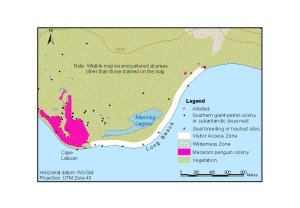
| Map Number | 13102 |
| Title | Long Beach, Heard Island |
| Edition | 1 |
| Scale | 1 : 29 250 |
| Publication date | August 2004 |
| Publisher |
Australian Antarctic Division (Australia)
|
| Spatial coverage |
( 73.4892° -53.1814°)
,
( 73.5314° -53.1814°)
,
( 73.5314° -53.1989°)
( 73.4892° -53.1989°) |
| Projection | Universal Transverse Mercator |
| Physical size | 6.7 x 9.7 cm |
| Notes | Map produced for the Heard and McDonald Islands Marine Reserve Management Plan 2005. |
| Keywords | Long Beach , Cape Labuan , Manning Lagoon , Topographic |
Downloads
This is a digital map available for downloading.
Map Lists
This map belongs to the following lists. Use the link on the list to see all maps belonging to that list
Additional Information
| Horizontal datum | WGS84 |
| Vertical datum | Mean sea level |
| Nomenclature | Australian Antarctic Gazetteer |
Preview