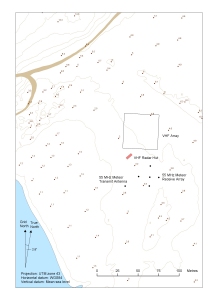
Map 13105: VHF radar at Davis Station, Antarctica
Map details
| Map Number | 13105 |
| Title | VHF radar at Davis Station, Antarctica |
| Edition | 1 |
| Scale | 1 : 1230 |
| Publication date | August 2004 |
| Publisher |
Australian Antarctic Division (Australia)
|
| Spatial coverage |
( 77.9897° -68.5758°)
,
( 77.9958° -68.5758°)
,
( 77.9958° -68.5792°)
( 77.9897° -68.5792°) |
| Projection | Universal Transverse Mercator |
| Physical size | - |
| Notes | The map shows the VHF radar, spot heights in metres, contour lines (heights in metres)and the nearby road. |
| Keywords | Vhf Radar , 55Mhz Meteor Transmit Antenna , 55 Mhz Meteor Receive Array |
Downloads
This is a digital map available for downloading.
Map Lists
This map belongs to the following lists. Use the link on the list to see all maps belonging to that list
Additional Information
| Horizontal datum | WGS84 |
| Vertical datum | Mean sea level |
Preview