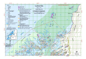
Map 13151: Vestfold Hills : Map 1 of 5
Map details
| Map Number | 13151 |
| Title | Vestfold Hills : Map 1 of 5 |
| Edition | 2 (Out of Date) |
| Previous edition | [Previous edition : 1] |
| Next Edition | [Next Edition : 3] |
| Scale | 1 : 50 000 |
| Publication date | September 2005 |
| Publisher |
Australian Antarctic Division (Australia)
|
| Spatial coverage |
( 78.1167° -68.3500°)
,
( 78.5833° -68.3500°)
,
( 78.5833° -68.4583°)
( 78.1167° -68.4583°) |
| Projection | Universal Transverse Mercator |
| Physical size | - |
| Keywords | Vestfold Hills , Zashchitnyye Islands , Tryne Islands , Wyatt Earp Islands , Mikkelsen's Cairn , Sir Hubert Wilkins Cairn , Snezhnyy Bay , Survey Marks , Topographic |
Downloads
This is a digital map available for downloading.
Map Lists
No maps lists available.
Additional Information
| Horizontal datum | WGS 84 |
| Vertical datum | Mean sea level |
| Nomenclature | Australian Antarctic Names Gazetteer |
Preview