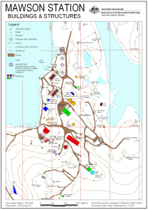
Map 13247: Mawson Station Buildings and Structures: without Management Zones
Map details
| Map Number | 13247 |
| Title | Mawson Station Buildings and Structures: without Management Zones |
| Edition | 1 |
| Scale | 1 : 3000 |
| Publication date | February 2006 |
| Publisher |
Australian Antarctic Division (Australia)
|
| Spatial coverage |
( 62.8681° -67.5989°)
,
( 62.8808° -67.5989°)
,
( 62.8808° -67.6054°)
( 62.8681° -67.6054°) |
| Projection | Universal Transverse Mercator |
| Physical size | 29.7 x 21 cm A4 |
| Notes | Modified from map number 13058 for inclusion in an educational atlas to be published by Pearson Education Australia in August 2006. |
| Keywords | Mawson Station , Buildings , Structures |
Downloads
This is a digital map available for downloading.
Map Lists
No maps lists available.
Additional Information
| Horizontal datum | WGS84 |
| Vertical datum | Mean sea level |
Preview