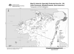
Map 13253: Antarctic Specially Protected Area No. 136 : Map B, Clark Peninsula, Windmill Islands, East Antarctica. Topography and bird distribution.
Map details
| Map Number | 13253 |
| Title | Antarctic Specially Protected Area No. 136 : Map B, Clark Peninsula, Windmill Islands, East Antarctica. Topography and bird distribution. |
| Edition | 2 (Out of Date) |
| Previous edition | [Previous edition : 1] |
| Next Edition | [Next Edition : 3] |
| Scale | 1 : 30 000 |
| Publication date | March 2006 |
| Publisher | - |
| Spatial coverage |
(110.5000° -66.2333°)
,
(110.6667° -66.2333°)
,
(110.6667° -66.2750°)
(110.5000° -66.2750°) |
| Projection | Universal Transverse Mercator |
| Physical size | - |
| Notes | Map included in the draft management plan 'Antarctic Specially Protected Area No.136, Clark Peninsula, Budd Coast, Wilkes Land.' |
| Keywords | Clark Peninsula , Windmill Islands , Antarctic Specially Protected Area No. 136 |
Downloads
This is a digital map available for downloading.
Map Lists
No maps lists available.
Additional Information
| Horizontal datum | WGS84 |
| Nomenclature | Australian Antarctic Names Gazetteer |
Preview