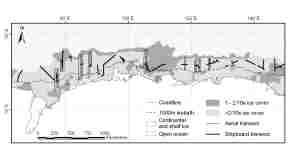
Map 13259: Crabeater seal survey 1999/2000: transects
Map details
| Map Number | 13259 |
| Title | Crabeater seal survey 1999/2000: transects |
| Edition | - |
| Scale | 1 : 30 000 000 |
| Publication date | March 2006 |
| Publisher |
Australian Antarctic Division (Australia)
|
| Spatial coverage |
( 60.0000° -58.0000°)
,
(150.0000° -58.0000°)
,
(150.0000° -75.0000°)
( 60.0000° -75.0000°) |
| Projection | Mercator |
| Physical size | 6.5 x 14 cm |
| Notes |
Produced by the Australian Antarctic Data Centre for Dr Colin Southwell, Australian Antarctic Division. Submitted for publication in the Journal of Applied Ecology and the Journal of Antarctic Science |
| Keywords | Crabeater , Seal , Transect , Ice , Cover , Ship Tracks |
Downloads
This is a digital map available for downloading.
Map Lists
This map belongs to the following lists. Use the link on the list to see all maps belonging to that list
Additional Information
Preview