Map 13292: Vestfold Hills: Map for Weddell Seal sightings
Map details
| Map Number | 13292 |
| Title | Vestfold Hills: Map for Weddell Seal sightings |
| Edition | 1 |
| Scale | 1 : 175 000 |
| Publication date | August 2006 |
| Publisher |
Australian Antarctic Division (Australia)
|
| Spatial coverage |
( 77.8000° -68.3333°)
,
( 78.5833° -68.3333°)
,
( 78.5833° -68.7083°)
( 77.8000° -68.7083°) |
| Projection | Universal Transverse Mercator |
| Physical size | 29.7 x 21 cm A4 |
| Notes |
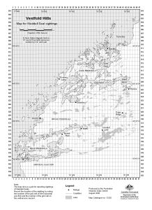
The map shows a grid for reporting sightings of Weddell seals. Record the location of the sighting by noting the number of the grid cell on the horizontal axis first and the number of the grid cell on the vertical axis second. This grid was originally displayed in a hard copy map, map 1758. Information about map 1758 and a digital version of the grid is available in a metadata record. |
| Keywords | reporting , grid |
Downloads
This is a digital map available for downloading.
Map Lists
This map belongs to the following lists. Use the link on the list to see all maps belonging to that list
Additional Information
| Horizontal datum | WGS84 |
| Vertical datum | Mean sea level |
Preview