Map 13322: Predicted Ross seal density
Map details
| Map Number | 13322 |
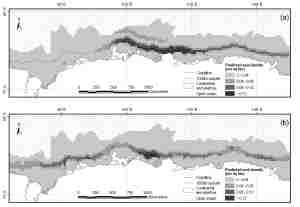
| Title | Predicted Ross seal density |
| Edition | 1 |
| Scale | 1 : 30 000 000 |
| Publication date | September 2006 |
| Publisher |
Australian Antarctic Division (Australia)
|
| Spatial coverage |
( 63.8167° -59.6500°)
,
(150.2500° -59.6500°)
,
(150.2500° -70.8000°)
( 63.8167° -70.8000°) |
| Projection | Mercator |
| Physical size | 10 x 14 cm |
| Notes |
Produced by the Australian Antarctic Data Centre for Dr Colin Southwell, Australian Government Antarctic Division. Map (a) shows predicted seal density from definite sightings. Map (b) shows predicted seal density from definite plus probable sightings Submitted for publication in Antarctic Science. |
| Keywords | Ross Seal Density , Seal Sightings |
Downloads
This is a digital map available for downloading.
Map Lists
This map belongs to the following lists. Use the link on the list to see all maps belonging to that list
Additional Information
| Horizontal datum | WGS84 |
Preview