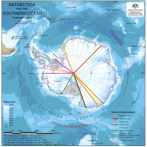
Map 13328: Antarctica and the Southern Ocean : Territorial Claims
Map details
| Map Number | 13328 |
| Title | Antarctica and the Southern Ocean : Territorial Claims |
| Edition | 1 |
| Scale | 1 : 45 000 000 |
| Publication date | February 2007 |
| Publisher |
Australian Antarctic Division (Australia)
|
| Spatial coverage |
(180.0000° -50.0000°)
,
(-180.0000° -50.0000°)
,
(-180.0000° -90.0000°)
(180.0000° -90.0000°) |
| Projection | Polar Stereographic |
| Physical size | 20 x 20 cm |
| Notes |
Information about data used in this map can be obtained by searching using the following Dataset ids: Antarctic Polar Front: Dataset 33 Maximum extent of sea ice: Dataset 181 (Qinfo 523) Bathymetry: Dataset 186 (Qinfos 534, 535, 537 to 540) Antarctica: Dataset 134 Territorial Claims: Dataset 108 |
| Keywords | Territorial Claims , Jurisdictional Boundaries , Polar Front , Maximum Extent , Sea Ice , Bathymetry |
Downloads
This is a digital map available for downloading.
Map Lists
This map belongs to the following lists. Use the link on the list to see all maps belonging to that list
Additional Information
Preview