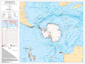
Map 13374: Antarctica and the Southern Ocean : Jurisdictional and Administrative Boundaries
Map details
| Map Number | 13374 |
| Title | Antarctica and the Southern Ocean : Jurisdictional and Administrative Boundaries |
| Edition | 3 |
| Previous edition | [Previous edition : 2] |
| Scale | 1 : 17 000 000 |
| Publication date | March 2007 |
| Publisher | - |
| Spatial coverage |
(-180.0000° -15.0000°)
,
(180.0000° -15.0000°)
,
(180.0000° -90.0000°)
(-180.0000° -90.0000°) |
| Projection | Polar Stereographic |
| Physical size | 86 x 116 cm |
| Notes | Includes a table listing the member countries of the Antarctic Treaty System, COMNAP, CEP, CCAMLR and SCAR. |
| Keywords | Antarctica , Southern Ocean , COMNAP , CCAMLR , SCAR , Antarctic Treaty , FAO , EEZ , Jurisdictional , Administrative Boundaries |
Downloads
This is a digital map available for downloading.
Map Lists
This map belongs to the following lists. Use the link on the list to see all maps belonging to that list
Additional Information
| Horizontal datum | WGS84 |
Preview