Map 13389: Mawson Station: Buildings and Structures
Map details
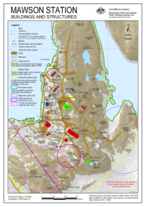
| Map Number | 13389 |
| Title | Mawson Station: Buildings and Structures |
| Edition | 8 (Out of Date) |
| Previous edition | [Previous edition : 7] |
| Next Edition | [Next Edition : 9] |
| Scale | 1 : 3000 |
| Publication date | December 2007 |
| Publisher |
Australian Antarctic Division (Australia)
|
| Spatial coverage |
( 62.8681° -67.5989°)
,
( 62.8808° -67.5989°)
,
( 62.8808° -67.6054°)
( 62.8681° -67.6054°) |
| Projection | Universal Transverse Mercator |
| Physical size | 29.7 x 21 cm A4 |
| Keywords | Station Limits , Magnetic Quiet Zone , Radio Frequency Interference Area , Cosmic Ray Laboratory Materials Free Zone |
Downloads
This is a digital map available for downloading.
Map Lists
No maps lists available.
Additional Information
| Horizontal datum | WGS84 |
| Vertical datum | Mean sea level |
Preview