Map 13448: Macaroni penguin guard stage foraging trips from Heard Island, 2003/04 summer
Map details
| Map Number | 13448 |
| Title | Macaroni penguin guard stage foraging trips from Heard Island, 2003/04 summer |
| Edition | 1 |
| Scale | 1 : 2 800 000 |
| Publication date | December 2007 |
| Publisher |
Australian Antarctic Division (Australia)
|
| Spatial coverage |
( 72.3333° -52.4167°)
,
( 76.0000° -52.4167°)
,
( 76.0000° -54.0000°)
( 72.3333° -54.0000°) |
| Projection | Universal Transverse Mercator |
| Physical size | 6.6 x 8.8 cm |
| Notes |
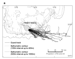
Inferred path of Macaroni penguin Eudyptes chrysolophus guard stage foraging trips from the colony at Capsize Beach on Heard Island. Data shown are based on satellite positions collected during a single trip for each bird and dietary information is available for each bird based on stomach contents collected at the end of the trip. All data were collected during the 2003/04 summer. Map published in the paper: Deagle, B.E., Gales, N.J., Hindell, M.A. (2008). Variability in foraging behaviour of chick-rearing Macaroni penguins Eudyptes chrysolophus and its relation to diet. Marine Ecology Progress Series vol 359: pp.295-309 |
| Keywords | Macaroni Penguin , Eudyptes Chrysolophus , Guard Stage , Foraging Trips , Capsize Beach , Heard Island , 2003/04 Summer |
Downloads
This is a digital map available for downloading.
Map Lists
This map belongs to the following lists. Use the link on the list to see all maps belonging to that list
Additional Information
Preview