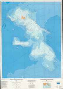
Map 13453: Bathymetric chart of the Kerguelen Plateau
Map details
| Map Number | 13453 |
| Title | Bathymetric chart of the Kerguelen Plateau |
| Edition | 1 |
| Scale | 1 : 5 000 000 |
| Publication date | 1987 |
| Publisher |
Bureau of Mineral Resources, Geology and Geophysics, Canberra (Australia)
Institut de Physique du Globe, Strasbourg (France) Terres Australes et Antarctiques Francaises, Paris (France) |
| Spatial coverage |
( 59.0000° -44.0000°)
,
( 88.0000° -44.0000°)
,
( 88.0000° -65.0000°)
( 59.0000° -65.0000°) |
| Projection | Mercator |
| Physical size | 96 x 68 cm |
| Notes | Reference : Schlich, R., Coffin, M.F., Munschy, M., Stagg, H.M.J., Li, Z.G., and Revill, K. 1987. Bathymetric chart of the Kerguelen Plateau. Jointly edited by Bureau of Mineral Resources, Geology and Geophysics, Canberra, Institut de Physique du Globe, Strasbourg, France, and Terres Australes et Antarctiques Francaises, Paris |
| Alternative title | Carte bathymetrique du Plateau de Kerguelen |
| Keywords | Kerguelen Plateau , Heard Island , Mcdonald Island , Bathymetry , Chart |
Downloads
This is a hard copy map that has been scanned. See information about obtaining copies of hard copy maps.
Map Lists
This map belongs to the following lists. Use the link on the list to see all maps belonging to that list
Additional Information
Preview