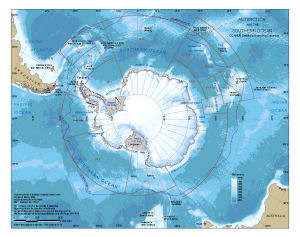
Map 13618: Antarctica and the Southern Ocean : CCAMLR statistical reporting subareas
Map details
| Map Number | 13618 |
| Title | Antarctica and the Southern Ocean : CCAMLR statistical reporting subareas |
| Edition | 1 |
| Scale | 1 : 44 000 000 |
| Publication date | March 2009 |
| Publisher | - |
| Spatial coverage |
(-180.0000° -30.0000°)
,
(180.0000° -30.0000°)
,
(180.0000° -90.0000°)
(-180.0000° -90.0000°) |
| Projection | Polar Stereographic |
| Physical size | 21.7 x 27.5 cm |
| Notes |
Map produced for Professor Michael Stoddart (Australian Antarctic Division) for the 2nd International Forum on the Sub-Antarctic, 26 - 27 April 2009, Hobart. The bathymetric data is from "Centenary Edition of the GEBCO Digital Atlas", 2003, published on behalf of the Intergovernmental Oceanographic Commission and the International Hydrographic Organization as part of the General Bathymetric Chart of the Oceans; British Oceanographic Data Centre, Liverpool. The coastline of Antarctica is from the Antarctic Digital Database version 4 © Scientific Committee on Antarctic Research 1993-2006. The Antarctic Polar Front is data described in Orsi, A. H., Whitworth III, T., and Nowlin, W. D. (1995), On the meridional extent and fronts of the Antarctic Circumpolar Current. Deep-Sea Research I, 42(5), 641-673. The CCAMLR Statistical Reporting Subareas were as described at the CCAMLR website when the map was produced. This map is similar to map number 13580 but has a greater extent to include Campbell Islands, Auckland Islands and Antipodes Islands. Map number 13989 is a similar map without the CCAMLR Statistical Reporting Subareas. |
| Keywords | Polar Front |
Downloads
This is a digital map available for downloading.
Map Lists
This map belongs to the following lists. Use the link on the list to see all maps belonging to that list
Additional Information
| Vertical unit | Metres |
Preview