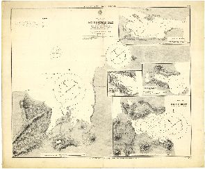
Map 1363: Accessible Bay, Kerguelen
Map details
| Map Number | 1363 |
| Title | Accessible Bay, Kerguelen |
| Edition | - |
| Scale | Not Entered |
| Publication date | - |
| Publisher | - |
| Spatial coverage |
( 68.4534° -48.4964°)
,
( 69.0549° -48.4964°)
,
( 69.0549° -49.9952°)
( 68.4534° -49.9952°) |
| Projection | Not Given |
| Physical size | - |
| Notes | With insets of Gazelle Basin, Christmas Harbour, Port Couvreux and Betsy Cove |
| Reference | 800 |
| Keywords | Captain J.K. Davis Collection , Historical |
Downloads
No downloads available.
Map Lists
This map belongs to the following lists. Use the link on the list to see all maps belonging to that list
Additional Information
Preview