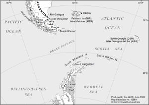
Map 13669: Antarctic Peninsula and Southern Tip of South America (Livingston Island labeled)
Map details
| Map Number | 13669 |
| Title | Antarctic Peninsula and Southern Tip of South America (Livingston Island labeled) |
| Edition | - |
| Scale | 1 : 21 500 000 |
| Publication date | June 2009 |
| Publisher |
Australian Antarctic Division (Australia)
|
| Spatial coverage |
( -85.0000° -48.0000°)
,
( -35.0000° -48.0000°)
,
( -35.0000° -72.0000°)
( -85.0000° -72.0000°) |
| Projection | Lambert Conformal Conic |
| Physical size | 12 x 17 cm |
| Keywords | Falkland Islands , South Georgia , South Orkney Islands , South Shetland Islands , Livingston Island , Topographic |
Downloads
This is a digital map available for downloading.
Map Lists
This map belongs to the following lists. Use the link on the list to see all maps belonging to that list
Additional Information
| Horizontal datum | WGS84 |
Preview