Map 13691: Glacial retreat on Heard Island
Map details
| Map Number | 13691 |
| Title | Glacial retreat on Heard Island |
| Edition | 1 |
| Scale | 1 : 134 857 |
| Publication date | August 2009 |
| Publisher |
Australia
|
| Spatial coverage |
( 73.0330° -52.6000°)
,
( 74.0330° -52.6000°)
,
( 74.0330° -53.6000°)
( 73.0330° -53.6000°) |
| Projection | Universal Transverse Mercator |
| Physical size | 29.7 x 42 cm A3 |
| Notes | Shrunk to about A5 for publication |
| Reference | Used in the publication "Remote Sensing HIMI Project 2008/2009 - Final report" by Dr Arko Lucieer, Angela Bender and Ursula Harris |
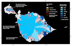
| Alternative title | Figure 2. Glacial extent at a range of dates derived from aerial photographs and satellite imagery. The latest digitised data is laid over the top. This map illustrates the glacial retreat on Heard Island. |
| Keywords | Heard , Lauren , Glacier , Extents , Ice-Cored Moraine |
Downloads
This is a digital map available for downloading.
Map Lists
This map belongs to the following lists. Use the link on the list to see all maps belonging to that list
Additional Information
| Horizontal datum | WGS84 |
Preview