Map 1371: Antarctic Ocean
Map details
| Map Number | 1371 |
| Title | Antarctic Ocean |
| Edition | - |
| Scale | Not Entered |
| Publication date | 1905 |
| Publisher | - |
| Spatial coverage |
(150.0000° -80.0000°)
,
(171.0000° -80.0000°)
,
(171.0000° -83.5000°)
(150.0000° -83.5000°) |
| Projection | Not Given |
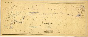
| Physical size | - |
| Notes | Chart showing sledge journey from "Discovery" Scott/Barnes - Part of Capt. J.K. Davis Collection. Scanned image available - please contact Aust. Antarctic Data Centre. Original map held at the National Archives of Australia (Hobart Office) |
| Reference | Sheet I |
| Keywords | Captain J.K. Davis Collection |
Downloads
No downloads available.
Map Lists
This map belongs to the following lists. Use the link on the list to see all maps belonging to that list
Additional Information
Preview