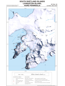
Map 13802: South Shetland Islands : Livingston Island, Hurd Peninsula
Map details
| Map Number | 13802 |
| Title | South Shetland Islands : Livingston Island, Hurd Peninsula |
| Edition | 1 |
| Scale | 1 : 75 000 |
| Publication date | March 2010 |
| Publisher |
UK Antarctic Place-names Committee (United Kingdom)
|
| Spatial coverage |
( -60.4758° -62.5322°)
,
( -60.0869° -62.5322°)
,
( -60.0869° -62.7683°)
( -60.4758° -62.7683°) |
| Projection | Polar Stereographic |
| Physical size | 50.1 x 33.1 cm |
| Notes |
Provisional for the positioning of place names Not to be used for navigational purposes |
| Reference | APC Misc 102 |
| Keywords | South Shetland Islands , Livingston Island , Hurd Peninsula , Apc Misc 102 , False Bay , Perunika Glacier , Huntress Glacier , Kaliakra Glacier , Huron Glacier , Charity Glacier , Mount Friesland , Mount Bowles , Macy Glacier , Survey Marks , Satellite Imagery |
Downloads
This is a digital map available for downloading.
Map Lists
No maps lists available.
Additional Information
| Horizontal datum | WGS1984 |
| Nomenclature | BAT Gazetteer |
Preview