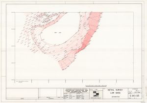
Map 13814: Detail Survey: Law Base (Sheet 1 of 2)
Map details
| Map Number | 13814 |
| Title | Detail Survey: Law Base (Sheet 1 of 2) |
| Edition | 1 |
| Scale | 1 : 500 |
| Publication date | 30 April 1990 |
| Publisher |
Australia
Australian Surveying and Land Information Group, Department of Administrative Services, Canberra (Australia) |
| Spatial coverage |
( 76.3784° -69.3890°)
,
( 76.3873° -69.3889°)
,
( 76.3875° -69.3907°)
( 76.3786° -69.3908°) |
| Projection | - |
| Physical size | 61 x 90.5 cm |
| Notes | Sheet 1 of a survey of Law Base in the Larsemann Hills by N. Peters and J. Hyslop. |
| Reference | Drawing no. E.90/23; File no. C.90/23 |
| Keywords | Survey Marks , Topographic |
Downloads
Map Lists
This map belongs to the following lists. Use the link on the list to see all maps belonging to that list
Additional Information
| Vertical datum | Mean Sea Level |
Preview