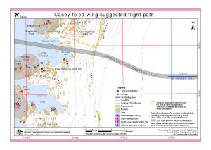
Map 13930: Casey fixed wing suggested flight paths
Map details
| Map Number | 13930 |
| Title | Casey fixed wing suggested flight paths |
| Edition | 3 (Out of Date) |
| Previous edition | [Previous edition : 2] |
| Next Edition | [Next Edition : 4] |
| Scale | 1 : 55 000 |
| Publication date | June 2012 |
| Publisher |
Australian Antarctic Division (Australia)
|
| Spatial coverage |
(110.4542° -66.2472°)
,
(110.7803° -66.2472°)
,
(110.7803° -66.3278°)
(110.4542° -66.3278°) |
| Projection | Universal Transverse Mercator |
| Physical size | 21 x 29.7 cm A4 |
| Keywords | ASPA 135 , ASPA 136 , Loken Moraines , Clark Peninsula , Whitney Point , Stonehocker Point , Wilkes , Newcomb Bay , Mcgrady Cove , Shirley Island , Mcmullin Island , Kilby Island , Beall Island , Mitchell Peninsula , Bailey Peninsula , Wilkes , O'brien Bay |
Downloads
This is a digital map available for downloading.
Map Lists
No maps lists available.
Additional Information
| Horizontal datum | WGS84 |
| Vertical datum | Mean Sea Level |
| Nomenclature | Australian Antarctic Gazetteer |
Preview