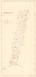
Map 14081: Macquarie Island
Map details
| Map Number | 14081 |
| Title | Macquarie Island |
| Edition | - |
| Scale | 1 : 75 400 |
| Publication date | 1943 |
| Publisher |
Government Printing Office (Australia)
|
| Spatial coverage |
(158.7333° -54.4250°)
,
(159.0167° -54.4250°)
,
(159.0167° -54.8167°)
(158.7333° -54.8167°) |
| Projection | Not Given |
| Physical size | 60 x 28.5 cm |
| Notes | Published as a folded map in the Australasian Antarctic Expedition 1911-14 Scientific Reports. Series A. Vol. 5 (1943) held in the Special Collection, Australian Antarctic Division Library |
| Keywords | A.R. Blake , Blake's Map , Australasian Antarctic Expedition 1911-14 , Topographic |
Downloads
This is a hard copy map that has been scanned. See information about obtaining copies of hard copy maps.
Map Lists
No maps lists available.
Additional Information
Preview