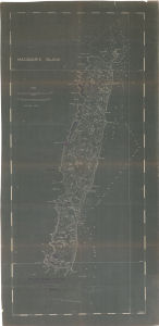
Map 14083: Macquarie Island
Map annotated with locations of giant petrel rookeries January, February 1961
Map details
| Map Number | 14083 |
| Title | Macquarie Island Map annotated with locations of giant petrel rookeries January, February 1961 |
| Edition | 1 |
| Scale | 1 : 32 180 |
| Publication date | - |
| Publisher | - |
| Spatial coverage |
(158.1667° -54.4167°)
,
(159.4167° -54.4167°)
,
(159.4167° -54.8167°)
(158.1667° -54.8167°) |
| Projection | Not Given |
| Physical size | 148 x 72.5 cm |
| Notes |
Annotated by John Warham showing giant petrel rookeries Jan/Feb 1961. Map based on Blake's map of Macquarie Island published in the Australasian Antarctic Expedition 1911-14 Scientific Reports. Series A, Vol. 5 (1943) |
| Keywords | Giant , Petrel , Rookeries , Rookery , 1961 , Warham |
Downloads
Map Lists
No maps lists available.
Additional Information
Preview