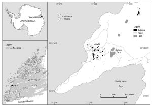
Map 14119: Davis with Vestfold Hills and Antarctica insets [Black and white]
Map details
| Map Number | 14119 |
| Title | Davis with Vestfold Hills and Antarctica insets [Black and white] |
| Edition | - |
| Scale | 1 : 14 000 |
| Publication date | August 2012 |
| Publisher |
Australian Antarctic Division (Australia)
|
| Spatial coverage |
( 77.9456° -68.5675°)
,
( 77.9939° -68.5675°)
,
( 77.9939° -68.5853°)
( 77.9456° -68.5853°) |
| Projection | Universal Transverse Mercator |
| Physical size | 14.2 x 20.4 cm |
| Notes | Includes a Vestfold Hills inset and an Antarctica inset |
| Keywords | Sorsdal Glacier , O'gorman Rocks , Station Tarn , Topographic |
Downloads
This is a digital map available for downloading.
Map Lists
This map belongs to the following lists. Use the link on the list to see all maps belonging to that list
Additional Information
| Horizontal datum | WGS84 |
Preview