Map 14141: Ardery Island, Windmill Islands
Map details
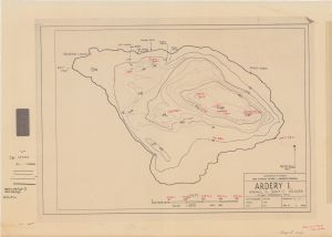
| Map Number | 14141 |
| Title | Ardery Island, Windmill Islands |
| Edition | 1 |
| Scale | 1 : 3000 |
| Publication date | 1963 |
| Publisher |
Australian Antarctic Division (Australia)
|
| Spatial coverage |
(110.4374° -66.3665°)
,
(110.4683° -66.3665°)
,
(110.4683° -66.3760°)
(110.4374° -66.3760°) |
| Projection | - |
| Physical size | 42 x 59.5 cm |
| Reference |
Sheet 1 H.O. 6656 Drawn by N. Orton |
| Keywords | Penney Landing , Soucek Ravine , Robertson Landing , Mast Point , Dingo Rock , Topographic |
Downloads
This is a hard copy map that has been scanned. See information about obtaining copies of hard copy maps.
Map Lists
No maps lists available.
Additional Information
Preview