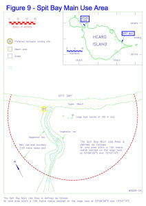
Map 14171: Spit Bay Main Use Area
Map details
| Map Number | 14171 |
| Title | Spit Bay Main Use Area |
| Edition | 1 |
| Scale | 1 : 1875 |
| Publication date | September 1995 |
| Publisher |
Australian Antarctic Division (Australia)
|
| Spatial coverage |
( 73.7189° -53.1064°)
,
( 73.7214° -53.1064°)
,
( 73.7214° -53.1083°)
( 73.7189° -53.1083°) |
| Projection | Not Given |
| Physical size | - |
| Notes |
Published in the Heard Island Wilderness Reserve management plan, Sept 1995 (Figure 6). Held in Australian Antarctic Division Library at 502.45(*785.1) Inset : Heard Island showing Spit Bay and Atlas Cove |
| Keywords | Spit Bay , Trypot Beach |
Downloads
Map Lists
This map belongs to the following lists. Use the link on the list to see all maps belonging to that list
Additional Information
| Nomenclature | Australian Antarctic Gazetteer |
Preview