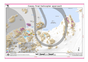
Map 14248: Casey final helicopter approach (Helicopter Operations)
Map details
| Map Number | 14248 |
| Title | Casey final helicopter approach (Helicopter Operations) |
| Edition | 4 (Out of Date) |
| Previous edition | [Previous edition : 3] |
| Next Edition | [Next Edition : 5] |
| Scale | 1 : 13 465 |
| Publication date | September 2013 |
| Publisher |
Australian Antarctic Division (Australia)
|
| Spatial coverage |
(110.5036° -66.2714°)
,
(110.5808° -66.2714°)
,
(110.5808° -66.2900°)
(110.5036° -66.2900°) |
| Projection | Universal Transverse Mercator |
| Physical size | 21 x 29.7 cm A4 |
| Keywords | - |
Downloads
This is a digital map available for downloading.
Map Lists
No maps lists available.
Additional Information
| Horizontal datum | WGS84 |
| Vertical datum | Mean sea level |
| Nomenclature | Australian Antarctic Gazetteer |
Preview