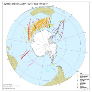
Map 14261: SCAR Southern Ocean CPR Survey Tows 1991-2013
Map details
| Map Number | 14261 |
| Title | SCAR Southern Ocean CPR Survey Tows 1991-2013 |
| Edition | 4 (Out of Date) |
| Previous edition | [Previous edition : 3] |
| Next Edition | [Next Edition : 5] |
| Scale | 1 : 35 000 000 |
| Publication date | October 2013 |
| Publisher |
Australian Antarctic Division (Australia)
|
| Spatial coverage |
(-180.0000° 0.0000°)
,
(180.0000° 0.0000°)
,
(180.0000° -90.0000°)
(-180.0000° -90.0000°) |
| Projection | Polar Orthographic |
| Physical size | 42 x 42 cm |
| Notes |
This map was produced by the Australian Antarctic Data Centre for Dr Graham Hosie (AAD). Some tow tracks from the 2009/10 to 2012/13 seasons were added to create this edition. |
| Keywords | Continuous Plankton Recorder , Ship Tracks |
Downloads
This is a digital map available for downloading.
Map Lists
This map belongs to the following lists. Use the link on the list to see all maps belonging to that list
Additional Information
| Horizontal datum | WGS84 |
Preview