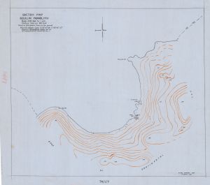
Map 14341: Scullin Monolith
Sketch Map
Map details
| Map Number | 14341 |
| Title | Scullin Monolith Sketch Map |
| Edition | - |
| Scale | 1 : 4800 |
| Publication date | July 1954 |
| Publisher |
Australia
|
| Spatial coverage |
( 66.6778° -67.7728°)
,
( 66.7406° -67.7728°)
,
( 66.7406° -67.7989°)
( 66.6778° -67.7989°) |
| Projection | - |
| Physical size | 58.5 x 64 cm |
| Notes |
The map was drawn by R. Dovers (ANARE Mawson 1954) based on photographs taken on the ground. It includes the location of the Weasel Camp, locations where geological specimens were collected and the location where No 1 Weasel was lost. Coverage is approximated |
| Reference | R. Dovers, Dovers' Map Collection |
| Keywords | Weasel , Camp , Geology , Geological , Topographic , Mac. Robertson Land |
Downloads
This is a hard copy map that has been scanned. See information about obtaining copies of hard copy maps.
- A print file (PDF)
- A LZW compressed TIFF
- National Library of Australia Bib ID 4492967 (External site)
Map Lists
This map belongs to the following lists. Use the link on the list to see all maps belonging to that list
Additional Information
| Magnetic variation | West 61°16' |
Preview