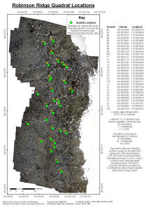
Map 14451: Robinson Ridge Quadrat Locations
Map details
| Map Number | 14451 |
| Title | Robinson Ridge Quadrat Locations |
| Edition | 1 |
| Scale | 1 : 400 |
| Publication date | May 2015 |
| Publisher |
The University of Wollongong (Australia)
|
| Spatial coverage |
(110.5850° -66.3676°)
,
(110.5866° -66.3676°)
,
(110.5866° -66.3689°)
(110.5850° -66.3689°) |
| Projection | Universal Transverse Mercator |
| Physical size | 42 x 29.7 cm A3 |
| Notes |
This map shows the locations of quadrats used for long term monitoring of vegetation on Robinson Ridge at Windmill Islands, Antarctica. The quadrats were established in 2002/03 under AAS Project 1313 and have been monitored at approximately five yearly intervals under this project and the subsequent AAS Project 4036 (Chief Investigator: Professor Sharon Robinson, University of Wollongong). The data are used for reporting on State of Environment Indicator 72. The quadrat locations are marked in the field with small metal tags glued to nearby rocks. Please avoid disturbing this area. Please take special care if approaching Robinson Ridge Hut from the north via Sparkes Bay. Pay attention to signs indicating the route to minimise damage to moss which may be under snow and is prone to damage if snow is compacted. |
| Keywords | - |
Downloads
Map Lists
No maps lists available.
Additional Information
| Horizontal datum | WGS84 |
Preview