Map 14471: Annex B: Macquarie Island Spill Risk Assessment Map Land - Based Spills
Map details
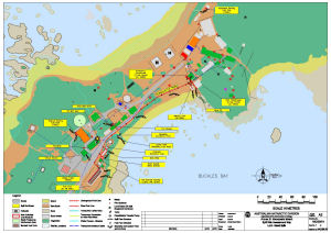
| Map Number | 14471 |
| Title | Annex B: Macquarie Island Spill Risk Assessment Map Land - Based Spills |
| Edition | 1 (Out of Date) |
| Next Edition | [Next Edition : 2] |
| Scale | 1 : 1300 |
| Publication date | 12 June 2002 |
| Publisher |
Australian Antarctic Division (Australia)
|
| Spatial coverage |
(158.9317° -54.4975°)
,
(158.9422° -54.4975°)
,
(158.9422° -54.5011°)
(158.9317° -54.5011°) |
| Projection | Universal Transverse Mercator |
| Physical size | 42 x 59.4 cm A2 |
| Notes | Map published in the Australian Antarctic Division fuel spill contingency plans. |
| Reference | MQ/02/01 |
| Keywords | Spill Risk , Drum Farm , Fixed Fuel Pipeline , Valve Drain Location , Valve Pit , Oil |
Downloads
This is a digital map available for downloading.
Map Lists
No maps lists available.
Additional Information
Preview