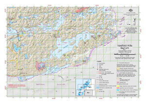
Map 14519: Vestfold Hills : Map 5 of 5
Map details
| Map Number | 14519 |
| Title | Vestfold Hills : Map 5 of 5 |
| Edition | 7 (Out of Date) |
| Previous edition | [Previous edition : 6] |
| Next Edition | [Next Edition : 8] |
| Scale | 1 : 50 000 |
| Publication date | August 2016 |
| Publisher | - |
| Spatial coverage |
( 78.1667° -68.5639°)
,
( 78.6500° -68.5639°)
,
( 78.6500° -68.6722°)
( 78.1667° -68.6722°) |
| Projection | Universal Transverse Mercator |
| Physical size | 29.7 x 42 cm A3 |
| Keywords | Crooked Lake , Chelnok Lake Lake Druzhby , Lebed Lake , Cat Lake , ASPA 143 , Pineapple Lake , Dismal Basin , Watts Lake , Canyon Lake , Cataract Canyon , Topographic |
Downloads
This is a digital map available for downloading.
Map Lists
No maps lists available.
Additional Information
| Horizontal datum | WGS 84 |
| Vertical datum | Mean sea level |
| Nomenclature | Australian Antarctic Gazetteer |
Preview