Map 14541: Traverse to proposed ice core drilling site 2016/17
Map details
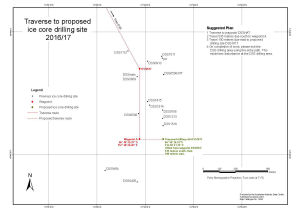
| Map Number | 14541 |
| Title | Traverse to proposed ice core drilling site 2016/17 |
| Edition | 6 |
| Previous edition | [Previous edition : 5] |
| Scale | 1 : 5500 |
| Publication date | November 2016 |
| Publisher |
Australian Antarctic Division (Australia)
|
| Spatial coverage |
(112.7856° -66.7650°)
,
(112.8328° -66.7650°)
,
(112.8328° -66.7783°)
(112.7856° -66.7783°) |
| Projection | Polar Stereographic |
| Physical size | 29.7 x 42 cm A3 |
| Notes | This map shows locations where ice cores have been taken at Dome Summit South, Law Dome, Antarctica and the proposed location for an ice core in the 2016/17 summer. |
| Keywords | - |
Downloads
This is a digital map available for downloading.
Map Lists
No maps lists available.
Additional Information
| Horizontal datum | WGS84 |
Preview