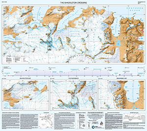
Map 15289: The Shackleton Crossing
Map details
| Map Number | 15289 |
| Title | The Shackleton Crossing |
| Edition | 2 |
| Scale | 1 : 40 000 |
| Publication date | 2017 |
| Publisher |
British Antarctic Survey (United Kingdom)
|
| Spatial coverage |
( -37.2833° -54.0833°)
,
( -36.6667° -54.0833°)
,
( -36.6667° -54.2167°)
( -37.2833° -54.2167°) |
| Projection | Lambert Conformal Conic |
| Physical size | 89 x 100 cm |
| Notes | This map is side B of a double-sided map with 'South Georgia' (Map Number 15288) published on the reverse. More information can be found at https://www.bas.ac.uk/data/our-data/maps/topographic-maps/south-georgia/. The map also contains three detailed 1:25,000 scale insets of key areas. |
| Reference | BAS (Misc) 12B |
| Keywords | South Georgia , Shackleton , Shackleton Crossing , Fortuna Bay , King Haakon Bay |
Downloads
No downloads available.
Map Lists
No maps lists available.
Additional Information
| Horizontal datum | WGS84 |
| Vertical unit | Metres |
| Nomenclature | UK Antarctic Place-names gazetteer |
Preview