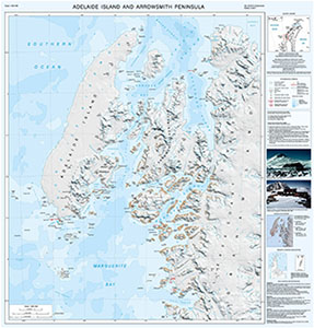
Map 15290: Adelaide Island and Arrowsmith Peninsula
Map details
| Map Number | 15290 |
| Title | Adelaide Island and Arrowsmith Peninsula |
| Edition | 2 |
| Previous edition | [Previous edition : 1] |
| Scale | 1 : 250 000 |
| Publication date | 2017 |
| Publisher |
British Antarctic Survey (United Kingdom)
|
| Spatial coverage |
( -69.5000° -66.5000°)
,
( -65.7500° -66.5000°)
,
( -65.7500° -68.3333°)
( -69.5000° -68.3333°) |
| Projection | Lambert Conformal Conic |
| Physical size | 88 x 84 cm |
| Notes | This is side A of a double-sided map. Side A shows Adelaide Island and Arrowsmith Peninsula as a satellite image mosaic. Side B shows the same area as a topographic map (Map Number 15303). More information can be found at https://www.bas.ac.uk/data/our-data/maps/topographic-maps/adelaide-island/ |
| Reference | SQ 19-20/14 (Extended) |
| Keywords | Adelaide Island , Rothera Point , Graham Land , Satellite image |
Downloads
No downloads available.
This is a hard copy map. See information about obtaining copies of hard copy maps.
Map Lists
This map belongs to the following lists. Use the link on the list to see all maps belonging to that list
Additional Information
| Horizontal datum | WGS84 |
| Vertical unit | Metres |
| Nomenclature | UK Antarctic Place-names gazetteer |
Preview