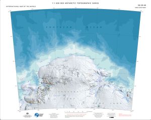
Map 15567: SQ 39-40
Map details
| Map Number | 15567 |
| Title | SQ 39-40 |
| Edition | 2 |
| Previous edition | [Previous edition : 1] |
| Scale | 1 : 1 000 000 |
| Publication date | December 2023 |
| Publisher |
Australian Antarctic Division (Australia)
|
| Spatial coverage |
( 48.0000° -64.0000°)
,
( 60.0000° -64.0000°)
,
( 60.0000° -68.0000°)
( 48.0000° -68.0000°) |
| Projection | Lambert Conformal Conic |
| Physical size | 54 x 68 cm |
| Reference | ISBN: 978-1-876934-51-4 |
| Alternative title | International Map of the World 1:1 000 000 |
| Keywords | Napier Mountains , Enderby Land , Kemp Land , Sakellari Peninsula , Amundsen Bay , Tula Mountains , Raggatt Mountains , Scott Mountains , King Edward Plateau , Edward Vii Gulf , Law Promontory , King Edward Ice Shelf , SQ39-40 , SQ39/40 , Survey Marks , Topographic |
Downloads
This is a digital map available for downloading.
- A print file (Georeferenced PDF)
- Georeferenced TIF
- 1M topographic series 2023 legend and data sources
Map Lists
This map belongs to the following lists. Use the link on the list to see all maps belonging to that list
Additional Information
| Horizontal datum | WGS84 |
| Vertical datum | Mean Sea Level |
| Vertical unit | Metres |
| Nomenclature | Australian Antarctic Gazetteer |
Preview