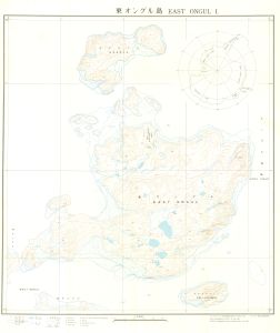
Map 2223: East Ongul Island
Map details
| Map Number | 2223 |
| Title | East Ongul Island |
| Edition | 1 |
| Scale | 1 : 5000 |
| Publication date | June 1957 |
| Publisher |
Geographical Survey Institute, Ministry of Construction (Japan)
|
| Spatial coverage |
( 39.5528° -68.9939°)
,
( 39.6222° -68.9939°)
,
( 39.6222° -69.0217°)
( 39.5528° -69.0217°) |
| Projection | Lambert Conformal Conic |
| Physical size | 76.5 x 59.5 cm |
| Notes | Detailed three-colour map compiled from JARE vertical air photography and ground control 1957. Contour interval: 2.5m. |
| Reference | S10/14 |
| Keywords | East Ongul Island , Reference Number S10/14 , Topographic |
Downloads
No downloads available.
Map Lists
No maps lists available.
Additional Information
Preview