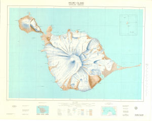
Map 28: Heard Island
Map details
| Map Number | 28 |
| Title | Heard Island |
| Edition | 2 (Out of Date) |
| Previous edition | [Previous edition : 1] |
| Next Edition | [Next Edition : 3] |
| Scale | 1 : 50 000 |
| Publication date | July 1977 |
| Publisher |
Department of National Development, Division of National Mapping (Australia)
|
| Spatial coverage |
( 73.2000° -52.9500°)
,
( 73.8500° -52.9500°)
,
( 73.8500° -53.2167°)
( 73.2000° -53.2167°) |
| Projection | Universal Transverse Mercator |
| Physical size | 79.5 x 99 cm |
| Reference | NMP 77/053 |
| Keywords | Big Ben , Laurens Peninsula , Spit Bay , Survey Marks , Topographic |
Downloads
This is a hard copy map that has been scanned. See information about obtaining copies of hard copy maps.
Map Lists
No maps lists available.
Additional Information
Preview