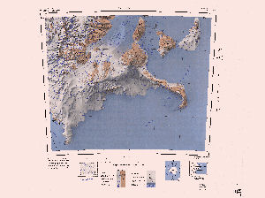
Map 3585: Mount Discovery
Map details
| Map Number | 3585 |
| Title | Mount Discovery |
| Edition | Rev.ed. |
| Previous edition | [Previous edition : 1] |
| Scale | 1 : 250 000 |
| Publication date | 1988 |
| Publisher |
US Geological Survey (United States of America)
|
| Spatial coverage |
(162.0000° -78.0000°)
,
(168.0000° -78.0000°)
,
(168.0000° -79.0000°)
(162.0000° -79.0000°) |
| Projection | Lambert Conformal Conic |
| Physical size | 66 x 76 cm |
| Notes | Antarctica 1:250,000 reconnaissance series |
| Reference | ST 57-60/10 |
| Keywords | St 57-60/10 , Mount Discovery , Minna Bluff , Royal Society Range , Koettlitz Glacier , Skelton Glacier , Black Island , White Island , Eady Ice Piedmont , Survey Marks , Topographic |
Downloads
Map Lists
This map belongs to the following lists. Use the link on the list to see all maps belonging to that list
Additional Information
| Vertical datum | Mean Sea Level |
| Nomenclature | U.S. Board on Geographic Names |
Preview