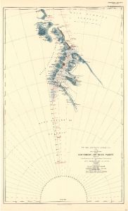
Map 3689: British Antarctic Expedition 1907 : Route and Surveys of the Southern Journey Party 1908-09
Map details
| Map Number | 3689 |
| Title | British Antarctic Expedition 1907 : Route and Surveys of the Southern Journey Party 1908-09 |
| Edition | - |
| Scale | 1 : 1 500 000 |
| Publication date | 1909 |
| Publisher |
Royal Geographical Society (United Kingdom)
|
| Spatial coverage |
(-100.0000° -82.0000°)
,
( 75.0000° -82.0000°)
,
( 75.0000° -90.0000°)
(-100.0000° -90.0000°) |
| Projection | Not Given |
| Physical size | 65.5 x 40 cm |
| Notes | From Traverses and Astronomical Observations by Eric Marshall, M.R.C.S., L.R.C.P. |
| Reference | 975 |
| Keywords | British Antarctic Expedition , Eric Marshall , King Edward Vii Plateau , Queen Alexandra Range , Beardmore Glacier , Mill Glacier , Ship Tracks , Historical |
Downloads
No downloads available.
This is a hard copy map. See information about obtaining copies of hard copy maps.
Map Lists
This map belongs to the following lists. Use the link on the list to see all maps belonging to that list
Additional Information
Preview