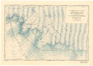
Map 3697: Australasian Antarctic Expedition : King George V Land showing tracks of the Eastern Sledging Parties from the Main Base
Map details
| Map Number | 3697 |
| Title | Australasian Antarctic Expedition : King George V Land showing tracks of the Eastern Sledging Parties from the Main Base |
| Edition | - |
| Scale | 1 : 1 000 000 |
| Publication date | 1914 |
| Publisher | - |
| Spatial coverage |
(142.0000° -66.4167°)
,
(153.0000° -66.4167°)
,
(153.0000° -69.1667°)
(142.0000° -69.1667°) |
| Projection | - |
| Physical size | 37 x 52 cm |
| Notes | Conical projection |
| Reference | 1085 |
| Keywords | Australasian Antarctic Expedition , King George V Land , Eastern Sledging Parties , Mertz Glacier , Ninnis Glacier , Adelie Land , King George V Land , Survey Marks , Historical , AAE |
Downloads
Map Lists
This map belongs to the following lists. Use the link on the list to see all maps belonging to that list
Additional Information
Preview