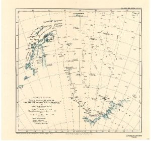
Map 3700: Antarctic Regions : chart to illustrate the paper on the Drift of the "Endurance" by Lieut. J.M. Wordie R.F.A.
Map details
| Map Number | 3700 |
| Title | Antarctic Regions : chart to illustrate the paper on the Drift of the "Endurance" by Lieut. J.M. Wordie R.F.A. |
| Edition | - |
| Scale | 1 : 7 500 000 |
| Publication date | April 1918 |
| Publisher | - |
| Spatial coverage |
( -85.0000° -58.3333°)
,
( -5.0000° -58.3333°)
,
( -5.0000° -79.0000°)
( -85.0000° -79.0000°) |
| Projection | Not Given |
| Physical size | 34 x 36.3 cm |
| Notes | A physical copy of this map is on permanent loan from the Australian Antarctic Division to the National Library of Australia, where it is available for viewing. |
| Reference | 1143 |
| Keywords | Endurance , J.M. Wordie , Ship Tracks , Historical |
Downloads
Map Lists
This map belongs to the following lists. Use the link on the list to see all maps belonging to that list
Additional Information
Preview