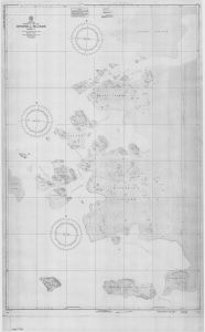
Map 5796: Windmill Islands - Sheet 1
Map details
| Map Number | 5796 |
| Title | Windmill Islands - Sheet 1 |
| Edition | 1 |
| Scale | 1 : 12 000 |
| Publication date | August 1956 |
| Publisher |
Defence Mapping Agency, Hydrographic Center (United States of America)
|
| Spatial coverage |
(110.4333° -66.2500°)
,
(110.6500° -66.2500°)
,
(110.6500° -66.3833°)
(110.4333° -66.3833°) |
| Projection | Mercator |
| Physical size | 132 x 91 cm |
| Notes | Hydrographic Chart. Compilation data: USNAE 1946-48, 1956-57; USNOO publications; misc. data |
| Reference | 16,520-1 |
| Keywords | Windmill Islands , Vincennes Bay , Budd Coast , Odbert Island , Ardery Island , Mitchell Island , O'Brien Islet , Beal Island , Bailey Island , Shirley Islet , Topographic |
Downloads
This is a hard copy map that has been scanned. See information about obtaining copies of hard copy maps.
Map Lists
No maps lists available.
Additional Information
| Vertical unit | Feet |
Preview