Chaos Glacier
Chaos Glacier (The name as it would appear in a gazetteer)
Chaos Glacier (The name as it would appear on a map)
If this information is incorrect, please e-mail mapping@aad.gov.au
Place ID: 2512
Name ID: 468
Feature type:
Glacier
Origin
This name originates from Australia.
It is part of the
Australian Antarctic Gazetteer and the SCAR Composite Gazetteer of Antarctica.
Names that other countries have for this feature:
Narrative
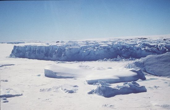
A glacier flowing into Ranvik Bay on the Ingrid Christensen Coast. Mapped by Norwegian cartographers from air photographs taken by the Lars Christensen Expedition (1936-37). Photographed by USN Operation Highjump and ANARE. Named by Dr J H Roscoe, after his 1952 study of Op Highjump air photos, due to the disturbed nature of the glacier. Dr Roscoe was photogrammetrist with USN Op Highjump (1946-47) and USN Op Windmill (1947-48).
Named For
Location
Latitude:
68° 59' 45.0" S
-68.99583°
Unknown precision
Longitude:
77° 59' 38.0" E
77.99389°
Unknown precision
Altitude:
Not recorded
Unknown precision
Images
©AAD, Copyright Commonwealth of Australia 1997
- Catalogue id
- 2283D2
- Caption
- [Location needs confirming]
- Photographer
- Houlahan, Darren
Map
Source
Location Method:
Satellite Image
Source Name:
LIMA - Landsat Image Mosaic Antarctica
Source Institution:
Australian Antarctic Division
Source Publisher:
USGS - United States Geological Survey
Remote sensing:
Not Applicable
Comments
None
Approval status
Date approved:
18-May-1971
Related information