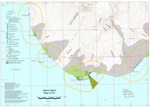
Map 12684: Heard Island Map 5 of 5
Map details
| Map Number | 12684 |
| Title | Heard Island Map 5 of 5 |
| Edition | 2 |
| Previous edition | [Previous edition : 1] |
| Scale | 1 : 50 000 |
| Publication date | December 2000 |
| Publisher |
Australian Antarctic Division (Australia)
|
| Spatial coverage |
( 73.3300° -53.0800°)
,
( 73.6500° -53.0800°)
,
( 73.6500° -53.2300°)
( 73.3300° -53.2300°) |
| Projection | Universal Transverse Mercator |
| Physical size | 29.7 x 42 cm A3 |
| Keywords | Heard Island , Henderson Bluff , Cape Pillar , Cape Arkona , Lied Glacier , Mawson Peak , Gotley Glacier , Fiftyone Glacier , Winston Glacier , Lambeth Bluff , Cape Labuan , Manning Lagoon , Long Beach , Lavett Bluff , Deacock Glacier , Dillon Hill , Budd Ridge , Topographic |
Downloads
This is a digital map available for downloading.
Map Lists
This map belongs to the following lists. Use the link on the list to see all maps belonging to that list
Additional Information
| Horizontal datum | WGS84 |
| Vertical datum | msl |
| Nomenclature | Australian Antarctic Names Gazetteer |
Preview