Map 13011: Physical features of the Southern Ocean
Map details
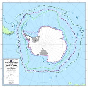
| Map Number | 13011 |
| Title | Physical features of the Southern Ocean |
| Edition | 1 |
| Scale | 1 : 20 000 000 |
| Publication date | September 2002 |
| Publisher |
Australian Antarctic Division (Australia)
|
| Spatial coverage |
(-180.0000° -35.0000°)
,
(180.0000° -35.0000°)
,
(180.0000° -90.0000°)
(-180.0000° -90.0000°) |
| Projection | Polar Stereographic |
| Physical size | 52 x 52 cm |
| Notes | The maximum and minimum sea ice extents were derived from passive microwave data (1989 to 1999) compiled at the Antarctic CRC, Australia. |
| Keywords | Southern Ocean , Sea Ice , Bathymetry , Front , Circumpolar , Maximum , Minimum |
Downloads
This is a digital map available for downloading.
Map Lists
This map belongs to the following lists. Use the link on the list to see all maps belonging to that list
Additional Information
| Horizontal datum | WGS84 |
Preview